Sometimes You Just Have a Bad Day Out on the Boat

Boating is usually always a lot of fun. I really can’t understand anyone not wanting to be out on the water. The fresh air and scenery can’t be beat although sometimes the sunshine is overdone here. But some days even being on the boat can be stressful.

Boating Pass For Merritt Island – Bring Cash!

A week or so ago we decided to try putting the boat in at a new boat ramp down on Merritt Island. Travel time to the ramp is about 30 minutes for us, but we needed to go even further to the Merritt Island Wildlife Refuge to buy a year-long pass. Each visit to a boat ramp will cost $10, but a year long pass is $25. Unfortunately they only accept CASH OR CHECK and all I had was $20 cash. My son was flipping out because who doesn’t take debit or credit cards?????? I have to agree. There was no ATM on the premises, so be aware of this if you plan to visit.

We ended up with a $10 day long pass.   My son was so mad I had to leave him in the truck and go back inside to buy it myself.

Strike one.  Time wasted, no year-long pass.  A visit all the way back down to the Refuge is the only way to attain a pass.

The Boat Ramp Was Horrible

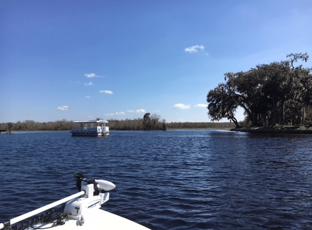
The boat ramp was alongside the eastern side of Mosquito Lagoon surrounded by very shallow water. It was a Wednesday, which is generally a slow boating day, and even though the ramp had good parking, there was one ramp and one narrow passageway to access the deeper water.  We found this ramp when we went to see the Falcon SpaceX rocket launch.

We were not impressed.  Maybe we will never use the ramp again – probably not.  But we maneuvered out to deeper water and then traveled north to the Haulover Canal. This is where we picked up the ICW to cross to the West side of the Lagoon.

Manatee Sightings – Good Part of the Day

This area (the Canal) is where manatees hang out, so going slow is key to avoid hitting them.  The water is very murky and we passed a manatee just inches from the side of our boat!  Because we are going slow, and our boat has a very shallow draft, the motor is unlikely to hit one of these creatures, but we kept a keen lookout for the telltale “bubble” of a swimming sea cow.

manatees
Group of manatees along the shore of the Haulover Canal

I did get this shot of a group of manatees gathered along the sandy shore of the Canal.  I had to blow it up and zoom in to show their gray bodies.  Hope you can see them okay.

So we saw manatees all along the canal, which is where the “Manatee Viewing Area” is, but something stunk really bad.  I think something had died because the stench in that part of the canal was disgusting.

Finding the Spoil Islands

We followed the ICW looking for the Spoil Islands, which are little islands in that area where boaters can visit and camp.  They can be rented, but I don’t know exactly how that works, or how you would keep other boaters off “your” island.  My son has been camping on the islands along the Indian River and he wanted to check out this new spot.

We wanted to find an empty island to hang out on, but the three we visited had people on them.  Because we didn’t want to go any further down south, we decided to head back.  I think the area is just too full of people (my complaint with most of Florida).

birds in mosquito lagoon
Birds on sandbar in Mosquito Lagoon

At a railroad bridge we headed out of the channel and landed at a little beach.  I did a little shell hunting and didn’t find anything interesting.  My son found this little shell on the bottom of his foot!  I had never seen one like it.  As you can see in my photos, it’s very tiny.  I believe it is called a Threeline Mudsnail.

mud snail
Tiny shell, I think is a Threeline mudsnail.

In this area, near the railroad track, I did some exploring while my son took the boat out to deeper water to try his luck at fishing. I’ll write about my Mosquito Lagoon shell-searching adventure in another post, but I did find some cool stuff.

A Bumpy Trip Back Home

By the time we left the area and headed back the wind had picked up. The waves were high enough to make for a very bumpy ride all the way to the ramp! I thought for sure my back would be sore as heck the following day, but it wasn’t too bad. My butt on the other hand was sore from all the bouncing.

We’ve had much better days out on the water and personally I don’t see any reason to go back down to Mosquito Lagoon. For fishermen it’s supposed to be one of the best places to catch fish. But the boat ramps on Merritt Island are horrible (and cost money), the waves can be high in the wide open area of the lagoon.  Our fishing boat is not made to run through constant waves comfortably.

The following day we went out over here near our home and had a great day… no hassles and all for free!

Boating on the St. Johns River, Taking a Break From Saltwater

A boat ride along the St. John’s River in Deland and Orange City.

A few days ago we decided to go boating on the St. John’s River. We always put in near our house and travel the ICW and backwater area to do some fishing. Saltwater is more fun, in my opinion, but fresh water boating gave us a nice break.
We put the boat in at the Ed Stone Park and Boat Ramp in Deland, and it was a really nice ramp. I didn’t take any photos of it – wish I had, but I was busy holding the boat.
There are five or six ramps with nice docks and plenty of parking for the trailers. This makes getting in and out of the water easy enough, and it’s free!
We went out on a Friday, and the weekends are no doubt much busier.
We headed south with no particular destination in mind.
boating on the St. John's River
We’d been boating on the river many years ago when we owned a pontoon boat. I’d caught a big black crappie back then which everyone told me (from looking at the picture) that it was record size. I knew nothing about fish or fishing at the time.

We noticed right away the high water line on the trees along the river. After Hurricane Irma (September 2017) we had heard stories about flooding along the St. John’s River. This river runs North, and that means when there is an abundance of rain in the south, it fills the river and brings all that water to the north.  So besides all the rain we got from the hurricane here, this part of the state also got runoff from the water dumped on south Florida.

The river had been closed to boaters for a long time because water was up in yards and flooding houses and businesses. We could see the water line among the trees and it was high! I would say 3 to 4 feet higher than what we were on. It was obvious to us that lots of places were not situated high enough above that line.

brown water
Brown water of the river

The river is not the place to swim as it is loaded with alligators. People do go in the water anyway and we saw a family fishing from the shore while their little girl splashed around in the water. Yikes.
The water is brown. It’s not dirty, but turns brown from something in the cypress trees that line the water. However this means you can’t see a thing beneath the surface. And there is creepy stuff in this water.

We saw quite a few alligators like the one slowly swimming in front of our boat while we were fishing.

alligator
Alligator swimming along the river

We traveled, very slowly due to all the “slow speed” signs, down toward Hontoon Island. The pontoon shuttle was going back and forth from the mainland to the island, which isn’t far at all.

pontoon boat at Hontoon Island
Hontoon Island (on the left) and the pontoon shuttle which goes back and forth to the mainland.

Further down the river we began to see lots of kayaks and activity. We were at Blue Springs state park. Boaters can pick a spot (if there is one) and tie up their boats to trees. It’s free to enter the park from a personal boat, but cars have to pay a fee.

They’ve made some nice upgrades to the Spring over the years, like this wooden boardwalk. I can’t remember exactly how it looked back in the 1980’s but I know it wasn’t this fancy.

Boardwalk at Blue Springs

We did some fishing and caught nothing, but we are not experts at fresh water fishing. Actually, we are not experts at all. Our trip was mainly for sight-seeing.  The trees along the banks looked ragged and many were torn up by the roots.

rivers edge
Shaggy trees at the edge of the river

Fish were jumping and birds lined the banks and sat in trees. Tour boats came by every now and then and loads of rented pontoon boats were out on the water. It’s easy to spot a rented boat when it says in big letters “Rent Me” on the side!

We saw a couple other fishing boats, but pontoons are the choice of travel here it seems. And it’s no wonder. Most of the river was marked with “Slow Speed” signs which meant it took us hours to travel down and back the short distance we went. This is because of the local manatee population.

If we go back to this boat ramp we will try going north instead of south. There were no slow speed signs up that way that we could see.

Outrunning A Rain Storm, Glad For the Bridge to Hide Beneath

While out boating on the Intracoastal waterway we began to hit some rainstorms. I took photos as we attempted to outrun the storms.

My son and I went out fishing all day a while ago and we ended up outrunning a rain storm. The day was mostly sunny with only spotty showers offshore, so we weren’t worried about getting wet. Our boat Hewes flats boat has no cover, but it was still hot enough that being wet wouldn’t be so bad.

As we traveled along the waterway, heading south from Edgewater, we looked for signs of hurricane Irma damage and we did see some. JB’s fish camp restaurant is open for business, but the docks were still being repaired (they have been fixed and are very nice).

Screen Shot 2017-10-20 at 11.04.41 AM

Then we headed back north towards the Marina, and Outriggers Restaurant, and the Bouchelle Condos (buildings with orange roofs in the photo below).   Continue reading “Outrunning A Rain Storm, Glad For the Bridge to Hide Beneath”